TO TOP

Projects at our Institute

Here you find a selection of our current and past projects!

Active

2023 - 2029
REPIC
Active
Erasmus Mundus Joint Masters, Redesigning the Post-Industrial City
Finanzierung
Europäische Kommission
2024 - 2028
Inner Map (ERC AdG)
Active
A novel approach to improved navigation performance through memory triggering maps
Optimizing navigation systems based on neurological evidence
Read more
Finanzierung
ERC Advanced Grant
2024 - 2027
Cartographic Cues (DFG)
Active
The impact of cartographic cues on neural representations of space
The project investigates how cartographic components affect spatial skills and memory on a neuroscientific level
Read more
Finanzierung
Deutsche Forschungsgemeinschaft
2023 - 2026
Shape2Gether
Active
Shaping innovations in education for sustainable development
In the Erasmus+ project Shape2Gether, researchers and students from various European universities are researching and implementing educational methods for sustainable development. The focus is on overcoming the challenges posed by climate change and its impact on Europe.
Finanzierung
Erasmus+
Partner
  • Technische Universität Wien
  • Norwegian University of Science and Technology
  • University of Turku
  • Universität Malta
  • seppo.io
  • Universität Utrecht
2023 - 2026
NFDI4Earth
Active
NFDI Consortium Earth System Research
The impact of human activity on nature is global and immense. Researchers are currently debating whether humanity is already in the Anthropocene, a new geological age. The causes of this great acceleration are complex and affect all spheres of the earth system.
Finanzierung
Deutsche Forschungsgemeinschaft (DFG)
Partner
  • TU Dresden
  • Alfred-Wegener-Institut Helmholtz-Zentrum für Polar- und Meeresforschung
  • Deutsches Klimarechenzentrum GmbH
  • Goethe-Universität Frankfurt am Main
  • Gottfried Wilhelm Leibniz Universität Hannover
  • Helmholtz-Zentrum Potsdam - Deutsches GeoForschungsZentrum (GFZ)
  • Hochschule Bochum
  • Karlsruher Institut für Technologie
  • Max-Planck-Gesellschaft zur Förderung der Wissenschaften e.V. (MPG)
  • Max-Planck-Institut für Biogeochemie (MPI-BGC)
  • Senckenberg Gesellschaft für Naturforschung (SGN)
  • Universität Leipzig
  • Bayerische Akademie der Wissenschaften
  • Brandenburgische Technische Universität Cottbus-Senftenberg
  • Bundesamt für Kartographie und Geodäsie (BKG)
  • Bundesamt für Seeschifffahrt und Hydrographie (BSH)
  • Bundesanstalt für Geowissenschaften und Rohstoffe (BGR)
  • Christian-Albrechts-Universität zu Kiel
  • Constructor University Bremen
  • Deutsche Allianz für Meeresforschung e.V. Wissenschaftsforum
  • Deutscher Wetterdienst (DWD)
  • Deutsches Archäologisches Institut (DAI)
  • Deutsches Zentrum für Luft- und Raumfahrt e.V. (DLR)
  • Eberhard Karls Universität Tübingen
  • Helmholtz-Zentrum Potsdam - Deutsches GeoForschungsZentrum (GFZ) Forschungsinstitut für Nachhaltigkeit (RIFS)
  • Forschungszentrum Jülich
  • Freie Universität Berlin
  • Friedrich-Alexander-Universität Erlangen-Nürnberg
  • Friedrich-Schiller-Universität Jena
  • GEOMAR Helmholtz-Zentrum für Ozeanforschung Kiel
  • Generaldirektion der Staatlichen Archive Bayerns
  • Georg-August-Universität Göttingen
  • HafenCity Universität Hamburg (HCU)
  • Helmholtz-Zentrum für Umweltforschung (UFZ)
  • Helmholtz-Zentrum hereon GmbH
  • Humboldt-Universität zu Berlin
  • Institute for Integrated Management of Material Fluxes and of Resources (UNU-FLORES)
  • Leibniz-Institut DSMZ-Deutsche Sammlung von Mikroorganismen und Zellkulturen GmbH
  • Leibniz-Institut für Angewandte Geophysik (LIAG)
  • Leibniz-Institut für Gewässerökologie und Binnenfischerei (IGB) im Forschungsverbund Berlin e.V.
  • Leibniz-Institut für Troposphärenforschung e.V. (TROPOS)
  • Leibniz-Institut für ökologische Raumentwicklung (IÖR) e.V.
  • Leibniz-Zentrum für Agrarlandschaftsforschung (ZALF) e.V.
  • Ludwig-Maximilians-Universität München
  • Museum für Naturkunde Leibniz-Institut für Evolutions- und Biodiversitätsforschung (MfN)
  • Potsdam-Institut für Klimafolgenforschung (PIK)
  • Rheinisch-Westfälische Technische Hochschule Aachen
  • Rheinische Friedrich-Wilhelms-Universität Bonn
  • Ruhr-Universität Bochum
  • Technische Informationsbibliothek (TIB)
  • Technische Universität Bergakademie Freiberg
  • Technische Universität Berlin
  • Technische Universität Braunschweig
  • Technische Universität Darmstadt
  • Technische Universität Dortmund
  • Technische Universität München (TUM)
  • Universität Bielefeld
  • Universität Bremen
  • Universität Hamburg
  • Universität Hohenheim
  • Universität Münster
  • Universität Potsdam
  • Universität zu Köln
  • Water Science Alliance e.V. c/o Technische Universität Dresden
2023 - 2026
Biodiversitäts-Exploratorien
Active
Biodiversitäts-Exploratorien
Die Exploratorien zur funktionellen Biodiversitätsforschung bieten eine Plattform für moderne, interdisziplinäre Forschungsansätze in der Biodiversitäts- und Ökosystemforschung.
2019 - 2026
BCC
Active
Balneário Camboriú Klima Projekt
A Brazilian research project that studies the interaction between the (vertical) urban development in Balneário Camboriú (the “Brazilian Dubai”) and its micro-climatic environment, via the research priorities.
  • Projekt Lead: Prof. Dr. Cássio Arthur Wollmann (Federal University of Santa Maria, UFSM)
  • Team: Prof. Dr. João Paulo Assis Gobo (the Federal University of Rondônia, UNIR), Prof. Dr. Júlio Barboza Chiquetto (Institute for Advanced Studies / Global Cities Program, IEA-USP), Dr. Salman Shooshtarian (Research Fellow School of Property, Construction and Project Management, RMIT University, Melbourne, Australia), Davi Hanel Rotilli Junior (Federal University of Santa Catarina), Dr. Matthias Demuzere (Ruhr-University Bochum)
  • Participating departments: Bochum Urban Climate Lab
  • Homepage: http://www.urban-climate.org/wp-content/uploads/newsletter/IAUC078.pdf
Read more
2022 - 2026
COINS
Active
COINS - Collaborative Project Land Management Sub-Saharan Africa: Joint Development of Innovations for Sustainable Land Management in Smallholder Farms in West Africa - Subproject 5: Knowledge Systems to Support SI Measures in Agricultural Reality
In COINS, methods of sustainable intensification of agriculture are being catalogued with a total of 14 German and African partners, evaluated in terms of their suitability in local contexts in innovation labs in Ghana and Senegal under real conditions, and the appropriate measures implemented on the ground.
Read more
Finanzierung
Bundesministerium für Bildung und Forschung
Partner
  • Deutsches Zentrum für Luft- und Raumfahrt (DLR), Deutsches Fernerkundungsdatenzentrum (DFD), Weßling
  • Leibniz-Zentrum für Agrarlandschaftsforschung e. V. (ZALF), Müncheberg
  • United Nations University Institute for Environment and Human Security (UNU-EHS), Bonn
  • Universität Hohenheim (UHOH), Stuttgart
  • Universität Bonn (UBonn), Institute of Crop Science and Resource Conservation (INRES), Institute for Food and Resource Economics (ILR), Bonn
  • University of Ghana (UGHA), Soil & Irrigation Research Centre, School of Agriculture, Accra, Ghana
  • United Nations University Institute for Natural Resources in Africa (UNU-INRA), Accra, Ghana
  • West African Science Service Centre on Climate Change and Adapted Land Use (WASCAL), Ouagadougou, Burkina Faso
  • International Crops Research Institute for the Semi-Arid Tropics (ICRISAT) and Manobi Africa Group Company, Dakar, Senegal
  • Initiative Prospective Agricole et Rurale (IPAR), Dakar, Senegal
  • Savanna Agriculture Research Institute (SARI), Tamale, Ghana
  • Agriculture and Climate Risk Enterprise Limited (ACRE Africa), Nairobi, Kenya
2021 - 2026
COST CA 20108
Active
Fair Network of Micrometerological Measurements
The COST FAIRNESS action intends to improve standardization and integration between databases/sets of micrometeorological measurements that are part of research projects or local/regional observational networks established for special purposes.
2024 - 2026
EO College 2026
Active
EO College 2026 - Learning environments of the future for earth observation
The EO-College project aims to promote knowledge about environmental technology by creating digital teaching material and establishing a suitable infrastructure for dissemination. The target groups are students at universities and schools.
Finanzierung
Deutsches Zentrum für Luft- und Raumfahrt (DLR)
Partner
Friedrich-Schiller-Universität Jena - Abteilung für Erdbeobachtung
2024 - 2025
MC2FM
Active
Participatory approach to mitigating the effects of climate change and reforesting the Muringato catchment area
The participatory project activates the community in the Muringato catchment area to assess climate change impacts, develop an early warning system for risky weather conditions and implement reforestation measures.
Finanzierung
BMBF
Partner
Dedan Kimathi University of Technology (DeKUT) – Institute of Geomatics, GIS & Remote Sensing (IGGReS)
2019 - 2025
MINT-Cluster
Active
Bochum MINT Education Cluster
The Bochum MINT Education Cluster is a core activity of the city of Bochum and has set itself the goal of inspiring pupils with various offers for the so-called MINT fields. It consists of 8 educational partners and has the motto "MINT education between heaven and earth".
Read more
Partner
  • Planetarium Bochum
  • Die Sternwarte
  • Die Hochschule Bochum
  • Ad Astra Bochum e.V.
  • Die AG Geomatik
  • Das Astronomische Institut der Ruhr-Universität Bochum
  • ESERO Germany
2020 - 2025
LELINA
Active
LELINA – Lern- und ErlebnisLabor IndustrieNAtur: Außerschulische Lernorte im Ruhrgebiet
Read more
Finanzierung
Bundesprogramm Biologische Vielfalt
Bundesamt für Naturschutz mit Mitteln des Bundesministeriums für Umwelt, Naturschutz, nukleare Sicherheit und Verbraucherschutz
Partner
Regionalverband Ruhr
Institut für Geographie und Sachunterricht der Bergischen Universität Wuppertal
Biologische Station Westliches Ruhrgebiet e. V. (BSWR)
Geographische Institut der Ruhr-Universität Bochum
2023 - 2025
CDEC
Active
Climate Data Entrepreneurial Club
The project is aimed at students in grades 10 to 13 (ages 16 to 19). Through easily customizable and expandable learning modules, they are trained in digital, AI and data literacy.
Finanzierung
Bundesministerium für Wirtschaft und Klimaschutz
Deutsches Zentrum für Luft- und Raumfahrt (DLR)
Partner
Gesellschaft für Informatik, Berlin
AG Didaktik der Informatik, Universität Paderborn
2023 - 2025
Copernicus4Schools
Active
Copernicus4Schools - The great disaster challenge
In mehreren nationalen Lehrplänen werden Themen im Zusammenhang mit Klima, Entwicklung und Nachhaltigkeit zunehmend in den Mittelpunkt gerückt. Daher ist das Wissen um die Nutzung von Satellitenbildern im Klassenzimmer zur Überwachung unseres Planeten von großem Nutzen für den täglichen Unterricht und zur Ergänzung vieler Lernziele.
Finanzierung
Europäische Union
Deutsches Zentrum für Luft- und Raumfahrt (DLR)
Partner
  • Norwegian Space Agency (NoSA)
  • Tartu Observatory (TO)
  • Portugal Space (PT Space)
  • Space, Security and Migration JRC (ISPRA)
  • Bulgarian Academy of Sciences (SRTI-BAS)
  • Cyprus University of Technology (CUT)
  • Charles University (CUNI)
  • German Aerospace Center (DLR)
  • Austrian Research Promotion Agency (FFG)
  • IHCantabria
  • National Institute of Aerospace Technology (INTA)
  • MeteoRomania
2021 - 2025
CORDEX URB-RCC
Active
URBan environments and Regional Climate Change
The main goal of this CORDEX Flagship Pilot Studies (FPS) project is to understand the effect of urban areas on the regional climate, as well as the impact of regional climate change on cities, with the help of coordinated experiments with urbanized RCMs.
2022 - 2025
ReNatUrE
Active
ReNatUrE: Wiederherstellung von städtischen Ökosystemen für biodiverse, lebenswerte und nachhaltige Städte in Europa
2024 - 2025
Active
Sustainability Academy
Finanzierung
Deutsche Bundesstiftung Umwelt
2019 - 2025
IMECOGIP
Active
IMECOGIP
IMECOGIP
IMECOGIP
IMECOGIP
Implementation of the ecosystem services concept in the planning of green infrastructure to strengthen the resilience of the Ruhr metropolis and Chinese megacities.
Read more
2020 - 2025
Active
Pagetitle
Read more
Finanzierung
Deutsche Forschungsgemeinschaft
2022 - 2025
LEIA
Active
LEIA - Lunar and Geoinformation Systems-based Analysis in Schools.
Global Crustal Thickness Map of the Moon with the help of Lunaserv GRAIL Crustal Thickness
The project aims to implement and utilize ideas and resources for the integration of astronautics, lunar and earth observation, and space exploration in the curriculum, by utilizing current developments and linking them to the goals of sustainable development.
Finanzierung
Deutsches Zentrum für Luft- und Raumfahrt (DLR)
Bundesministerium für Wirtschaft und Klimaschutz der Bundesrepublik Deutschland (BMWK)
2018 - 2025
ESERO
Active
European Space Education Resource Office (ESERO) Germany
ESERO Germany brings outer space into the classroom with innovative and exciting teaching materials for the MINT subjects (mathematics, computer science, natural sciences, technology)
ESERO Germany brings outer space into the classroom with innovative and exciting teaching materials for the MINT subjects (mathematics, computer science, natural sciences, technology). ESERO Germany
ESERO Germany is a joint project of ESA and the German Aerospace Center (DLR). The aim of ESERO Germany is to get pupils interested in STEM subjects. To this end, space topics are integrated into school lessons in an exciting and innovative way and pupils' skills in the subjects of mathematics, computer science, natural sciences and technology are promoted.
Read more
Finanzierung
Europäische Weltraumorganisation
Partner
  • Geographisches Institut der Ruhr-Universität Bochum
  • Zeiss Planetarium Bochum
  • Das Astronomische Institut der Ruhr-Universität Bochum
  • Die Sternwarte Bochum
  • Die Universität Bonn mit der Remote Sensing Research Group des Geographischen Instituts, dem Physikalischen Institut und dem Argelander Institut für Astronomie
  • Das Institut für Physikdidaktik der Universität zu Köln
  • Das zdi.NRW – Zukunft durch Innovation
  • Ignite education GmbH in Kooperation mit dem Deutschen Zentrum für Luft- und Raumfahrt e.V.
2023 - 2025
Active
Ogun State Economic Development Clusters Initiative and its Implications on Settlement Expansion and Ecosystems in Abeokuta: An Agent Based Modelling of Secondary Cities in a Developing Country
Finanzierung
Alexander-von-Humboldt-Stiftung
2022 - 2024
HORIZON-CL5-2021-D2-01
Active
TRANSFORMER
2023 - 2024
Cop4Schools
Active
Cop4Schools - Crossing borders in education
Methods and techniques of remote sensing and digital image processing are used intensively in our society, but a sound background knowledge is not widespread. Space technology and Earth observation are key activities for our society in terms of research, innovation and the economy, but also for the fulfillment of the development goals of the UN 2030 Agenda.
Finanzierung
Europäische Union
Deutsches Zentrum für Luft- und Raumfahrt (DLR)
Partner
Tartu Observatory
2020 - 2024
Active
Role of rhizobacteria-mycorrhizae-plants symbioses on the improvement of soil quality polluted by mine discharges.
Read more
Finanzierung
Alexander von Humboldt Stiftung
2022 - 2024
Sustainable Urbanization
Active
Sustainable Urbanization: A Retrospective and Prospective Policy Analysis of Five Fastest Growing African Cities Using Remote Sensing Data and Machine Learning
The aim of the project is to identify the underlying factors and patterns of rapid urban expansion and related policies in six of the fastest growing African cities in order to anticipate future urban growth dynamics and their challenges towards sustainable development.
Read more
2020 - 2024
Active
Pagetitle
Read more
Finanzierung
Deutsche Forschungsgemeinschaft
2021 - 2024
VR Lectures (MSB NRW)
Active
Virtual Reality in Schools
The aim of the research project funded by the Ministry of School and Education NRW is to create interactive virtual reality environments and to evaluate their use in geography lessons.
  • Projekt Lead: Marco Weißmann
  • Team: Marco Weißmann, Prof. Dr. Frank Dickmann, PD. Dr. Dennis Edler
  • Participating departments: Cartography
Read more
Finanzierung
Ministerium für Schule und Bildung des Landes Nordrhein-Westfalen
2021 - 2024
Clim4Edu
Active
Clim4Edu - Development and production of teaching materials for schools on the subject of climate change using satellite data.
Clim4Edu: The new project on climate change education with satellite data
Studying and understanding climate change requires an understanding of complex research methods and relationships that combine physics, geography, chemistry and other sciences. Clim4Edu prepares these for the classroom with a focus on satellite analysis.
Read more
Finanzierung
Deutsches Zentrum für Luft- und Raumfahrt (DLR)
Bundesministerium für Wirtschaft und Klimaschutz der Bundesrepublik Deutschland (BMWi)
Partner
Institut für Umweltphysik, Universität Bremen
2023 - 2024
EBOVE
Active
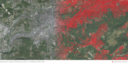
Capturing the impervious surface area throughout North Rhine-Westphalia to determine the soil sealing indicator
Sealed surfaces in the urban area of Wuppertal. Left: Digital orthophoto (2021), Right: Overlay with created sealing layer
Sealed surfaces in the urban area of Wuppertal. Left: Digital orthophoto (2021), Right: Overlay with created sealing layer. Jan-Philipp Langenkamp 2023. Quelle: Digitale Orthophotos (2021), © GeoBasis NRW 2023
The remote sensing-based recording of land sealing for the federal state of NRW is planned. Based on these results, a "sealing" indicator will be created to provide information on the development of land sealing in NRW. The aim is to use the created method in a central calculation service for NRW.
Read more
Finanzierung
Landesamt für Natur, Umwelt und Verbraucherschutz NRW (LANUV)
Partner
Landesamt für Natur, Umwelt und Verbraucherschutz NRW (LANUV)
2022 - 2024
OER4SDI
Active
OER4SDI - Open Educational Resources for Spatial Information Infrastructures
The goal of the OER4SDI project is the development and publication of a structured and coherent collection of CC-licensed OER materials that will support students in the teaching subjects of geoinformation processing (e.g., geoinformatics, geodesy, geomatics) to gain a comprehensive understanding of the architecture, implementation, and use of spatial data infrastructures.
Read more
Finanzierung
Ministerium für Kultur und Wissenschaft des Landes Nordrhein-Westfalen (MKW NRW)
Partner
Westfälische Wilhelms-Universität - Institut für Geomatik
Fachhochschule Bochum - Fachbereich Geodäsie
2021 - 2024
VGIscience (DFG)
Active
The Effects of Landmark Uncertainty in VGI-based Maps
Approaches to Improve Wayfinding and Navigation Performance
Read more
Finanzierung
DFG Schwerpunktprogramm, SPP 1894
2021 - 2024
Active
Re-configuration of territories and autonomy strategies under corporate food regime
The research seeks to integrate the analysis of power structures with spatial components of the territory. The aim is to understand how communities impacted by inflow of international capital developed autonomous strategies in (re)structuring their territory of local food systems and how principles of food sovereignty are applied.
Finanzierung
Deutscher Akademischer Austauschdienst (DAAD)
2021 - 2024
Active
Spatial empowerment through real estate development strategies in the context of urban renewal of devastated areas. Case study: Damascus metropolitan area
The aim is to consolidate the spatial empowerment concept through real estate development strategies to overcome problems within the urban renewal process, by integrating the mitigation and adaptation principles as integral to both the pre-and post-disaster phases.
Read more
Finanzierung
Deutscher Akademischer Austauschdienst (DAAD)
2020 - 2023
Active
Social segregation in neighborhood and school
2017 - 2023
KoMet
Active
Pagetitle
Finanzierung
Seit 2018 Stiftung Mercator, 2017 Mercator Research Centre Ruhr
2019 - 2023
Active
Contingency of urban greens
2021 - 2023
DigiGeo
Active
DigiGeo-Transferring contact, technology- and field-based education to digital: methods and tools for geosciences training
2022 - 2023
Active
Erasmus Mundus Design Measures, Redesgining the Post-Industrial City
Finanzierung
Europäische Kommission
Since 2021
Active
Release and dissipation of antibiotics and disinfectants in different soil types depending on the quality of irrigation.
Since 2020
Active
Sorption thermodynamics and aggregation as controlling factors for microbial substrate utilization and mineralization.
Since 2017
Industriewald Ruhrgebiet
Active
Read more
Finanzierung
Ministerium für Landwirtschaft und Verbraucherschutz
Ministerium für Umwelt, Naturschutz und Verkehr
Partner
Biologische Station westliches Ruhrgebiet
Wald und Holz NRW
LANUV NRW
Since 2016
Wudapt
Active
The World Urban Database and Access Portal Tools Project
The World Urban Database and Access Portal Tools project is a bottom-up initiative to collect data on the form and function of cities around the world.
Read more
Since 2023
D2R
Active
Data2Resilience
The project "Data2Resilience" focuses on data-driven measures and services for monitoring thermal comfort within the city of Dortmund. The aim is to enhance resilience to extreme heat in Dortmund sustainably and optimize energy efficiency in both building structures and urban infrastructure.
Since 2020
ENLIGHT
Active
ENablig the anaLysIs of Global urban HeaT
The overreaching goal of the project is to develop a consistent and generic methodology that enables globally consistent analysis of urban heat islands worldwide. This is done via satellite earth observation and crowdsourcing.
Since 2023
CARMINE
Active
Climate-Resilient Development Pathways in Metropolitan Regions of Europe
The aim of this EU-project is the development of climate resilient adaptation strategies, knowledge-based tools and strategies as well as services for eight metropolitan areas within Europe through the linkage and collaboration of different stakeholders and science communities with the help of e.g. Living Labs, nature-based solutions and modelling.
Since 2020
Urban PLUMBER
Active
A multi-model, multi-site benchmarking evaluation project for urban areas
Since 2023
Celtic Fields
Active
Celtic Fields
Read more
Since 2023
WATCH
Active
Water for Children in Climate Change
The "WATCH" project investigates the hydration needs and risk of dehydration in young children under urban climate conditions and climate change-induced climatic variations. The aim is to provide drinking recommendations and thereby reduce the risk for this vulnerable age group.
Read more
Since 2022
BoKliNet
Active
Klimanetzwerk Bochum
As part of the Bochum climate network, over 20 weather stations are to be set up at Bochum schools. This measurement network makes it possible to model the different climatic conditions in Bochum. The main goal is for students to actively learn in class how data can be collected, managed, evaluated and combined with other environmental data.
Since 2023
Humus
Active
Humus Monitoring
Read more
Partner
Geologischer Dienst NRW
LANUV
Since 2021
QAAC
Active
Increasing consumption of quaternary ammonium compounds during the SARS-CoV-2 pandemic
Impacts on concentrations in the environment and development of multi-resistance in pathogens and environmental bacteria.

Proposed

2024 - 2027
PROMETHEUS
Proposed
Development of innovative mapping methods
Read more
Finanzierung
DGfK (beantragt)

Completed

2022 - 2024
Nightlights
Completed
Nightlights
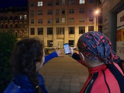
Nachtlichter app observation
Nachtlichter app observation. Stefanie Partsch (2021). Image shows two people using the night lights app to categorize an outdoor light source
Artificial light at night is a growing environmental problem with impacts on plants, animals and humans. Data on light pollution or light sources on the ground is largely lacking. With our project "Night Lights", we invite all people to record light sources in their environment with the Night Lights app.
Finanzierung
Bundesministerium für Bildung und Forschung
Partner
Deutsches Zentrum für Luft- und Raumfahrt (DLR)
Deutsches GeoForschungsZentrum GFZ
2019 - 2023
EO-College
Completed
EO-College - Promoting application-oriented training in Earth observation
EO College - Logo
EO College - Logo. EO College
The EO College project wants to foster EO knowledge by creating digital teaching material and establishing an appropriate infrastructure for dissemination. Target groups are university level students as well as schools.
Read more
Finanzierung
Bundesministerium für Wirtschaft und Klimaschutz der Bundesrepublik Deutschland (BMWK)
Partner
Friedrich-Schiller-Universität Jena - Abteilung für Erdbeobachtung
2023 - 2023
GeNaMo
Completed
Healthy and sustainable mobility in socially disadvantaged neighborhoods
The project aims to evaluate existing interventions and then design and implement new interventions. Building on this, the aim is to promote sustainable walking activities and thus the health of city dwellers.
Finanzierung
Bundesministerium für Bildung und Forschung
Partner
Fakultät für Sportwissenschaft, Ruhr-Universität Bochum
Institut für Angewandte Bewegungswissenschaften, Technische Universität Chemnitz
2020 - 2023
EO4Edu
Completed
"EO4Edu – Earth Observation for Education"
EO4Edu: internationales Erasmus+ - Projekt
EO4Edu: internationales Erasmus+ - Projekt "Earth Observation for Education"
EO4Edu introduces Earth observation to schools across Europe by teaching the basics of remote sensing, earth sciences and satellite-based Earth observation in an application-oriented way. In collaboration with partner schools and universities in Wales, the Czech Republic, Greece and Bochum, innovative interdisciplinary teaching and learning materials are developed and tested in real-life settings
2020 - 2023
EO-CONNECT
Completed
EO Connect – Promoting global networking in Earth observation education, sub-project: Innovative learning methods and school education
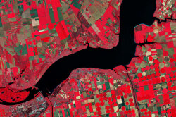
This false-colour image is a detail of a picture taken of southern Ukraine. The near-infrared channel that was included makes vegetation appear bright red. The image contains on modified 2019 Copernicus Sentinel data processed by ESA, CC BY-SA 3.0 IGO
Read more
Finanzierung
Bundesministerium für Bildung und Forschung (BMBF)
Partner
Friedrich-Schiller-Universität Jena - Abteilung für Erdbeobachtung
2020 - 2023
CITGI4Muringato
Completed
CITGI4Muringato – Participatory Approach to Environmental Conservation of the Muringato Catchment Area for Sustainable Management and Enhanced Ecosystem Health
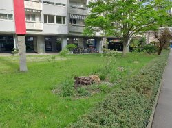
Marcus Goebel. Crowd mapping, Muringato flow, fieldwork and land cover classification
The project objective is to develop a sustainable environmental monitoring and management of water resources in the Muringato sub-basin in central Kenya. This includes the joint use of remote sensing and citizen science approaches well as the use of e- and m-learning technologies.
Read more
Finanzierung
BMBF
Partner
Dedan Kimathi University of Technology (DeKUT) – Institute of Geomatics, GIS & Remote Sensing (IGGReS)
2018 - 2022
Completed
Pagetitle
Finanzierung
Land NRW
Partner
Staatskanzlei NRW
KoMet
Regionalverband Ruhr
2019 - 2022
SPATIONOMY 2.0
Completed
SPATIONOMY 2.0 - Spatial and economic science in higher education - addressing the playful potential of simulation games
2020 - 2022
Geodata-Curriculum (Stifterverband)
Completed
Curriculum 4.0
  • Projekt Lead: Dr. Julian Keil
  • Team: Dr. Julian Keil, Prof. Dr. Frank Dickmann, Prof. Dr. Thomas Schmitt
  • Participating departments: Cartography
Read more
Finanzierung
Stifterverband und Land NRW
2018 - 2022
Elvic
Completed
Climate extremes in the lake Victoria Basin
Read more
2017 - 2022
Sublime
Completed
Single-column Urban Boundary Layer Inter-comparison Model Experiment
Read more
2019 - 2022
MOOC4Land
Completed
MOOC4Land - Developing a Massive Open Online Course on EO Land Applications
2017 - 2022
KEPLER ISS
Completed
KEPLER ISS - Kompetenzorientiertes, erfahrungsbasiertes und praktisches Lernen mit Erdbeobachtung von der ISS
The Columbus Eye web portal is intended to bring teachers and students and all interested parties closer to the images and videos from the ISS and especially to get students excited about the activities on and above our planet.
Finanzierung
BMWi
DLR
2020 - 2021
RASSMT
Completed
Pagetitle
Finanzierung
Ministerium für Heimat, Kommunales, Bau und Gleichstellung des Landes Nordrhein-Westfalen
2017 - 2021
React
Completed
Remote sensing for malaria epidemiology in African cities
Read more
2019 - 2021
Completed
Machbarkeitsstudie über die Prognosemöglichkeiten von Investitionen und Exporten mit unkonventionellen Datenquellen und Methoden
2016 - 2020
APHH China
Completed
Atmospheric Pollution and Human Health in a Chinese Megacity
APHH is an international collaborative project to examine the emissions, processes and health effects of air pollution in Beijing.
  • Team: Natural Environment Research Council (NERC), Medical Research Council (MRC), National Natural Science Foundation of China (NSFC)
  • Participating departments: Bochum Urban Climate Lab
  • Homepage: http://aphh.org.uk/
Read more
1995 - 2020
ESA CCI
Completed
ESA Climate Change Initiative Land Surface Temperature Project
The ESA Climate Change Initiative (CCI) aims to realize the full potential of the long-term global Earth Observation archives that ESA has established over the past 30 years, as a significant and timely contribution to the ECV databases required by UNFCCC.
2017 - 2020
KlimNet
Completed
KlimNet: City and country in flux - Network for the design of a sustainable climate landscape
2017 - 2020
VGIscience (DFG)
Completed
The Effects of Landmarks on Navigation Performance in VGI-based Maps
Research into the influence of landmark representations in maps on position and route memory.
Read more
Finanzierung
DFG Schwerpunktprogramm, SPP 1894
2019 - 2020
Completed
PagetitleKartierung der Überprägung naturnaher Böden durch kriegsbedingte Einflüsse in Gelsenkirchen
Read more
Finanzierung
Stadt Gelsenkirchen
2017 - 2020
FIS-III
Completed
Remote Sensing in Schools III - FIS-III
2016 - 2019
Transpirant
Completed
Evaporation of precipitation water as a new approach to climate change adaptation
Read more
2016 - 2019
Completed
Pagetitle
2014 - 2019
HDEV
Completed
High Definition Earth Viewing
2016 - 2019
HDEV-Wetter
Completed
Sifting of HDEV data for weather reporting - weather observation and media processing
Contract project of the DLR
2019 - 2019
Welt in Pixeln
Completed
The World in Pixels - From Measured Values to Facts?
Verbundprojekt gefördert durch das Alfried-Krupp Schülerlabor
Partner
Alfried-Krupp Schülerlabor
2016 - 2018
Industrie-Zentren in Karten (DPWS)
Completed
The Cultural Landscape Development of Polish and German Industrial Centres
German-Polish joint project between the Ruhr University Bochum and the Adam Mickiewicz University Poznań
  • Projekt Lead: Prof. Dr. Frank Dickmann
  • Participating departments: Cartography
Read more
Finanzierung
Deutsch-Polnische Wissenschaftsstiftung, DPWS
2012 - 2018
Kognitionsprinzipien in Karten (DFG)
Completed
Spatial Distortions in Cognitive Maps
A Chance and Challenge to Enrich the Principles of Map Design
Read more
2014 - 2017
Plan4Chance
Completed
Plan4Change
New approaches to climate-adapted urban planning using the example of the "Quartier Feldmark" model area
Read more
2015 - 2017
StaKLiBo
Completed
Stadt - Klima - Boden
Activation of the ground cooling capacity for urban climate concepts for climate adaptation using the example of the city of Neuss
Read more
2013 - 2017
Columbuseye
Completed
Columbus Eye - live images from the ISS in the classroom
2015 - 2016
REHIN
Completed
Settlement development in the Rhineland metropolitan region
Commissioned project of the district governments of Düsseldorf and Cologne
2010 - 2015
Completed
Pagetitle
2010 - 2014
Lentikular-Karten (DFG)
Completed
Lenticular generation of thematic cartographic multi-image models
Read more
Finanzierung
Deutsche Forschungsgemeinschaft (DFG)