![]()
![]()
![]()
![]()
Industrial centres in comparison
Montan regions such as the Ruhr area or the Upper Silesian Industrial Area (Poland) have undergone a comprehensive transformation of their cultural landscape since industrialisation in the 19th century. Characteristic for this development are above all massive urbanisation processes that took place within a few decades. Compared to neighbouring regions, Upper Silesia and the Ruhr area experienced rapid economic and socio-spatial change. Both areas are among the most populous regions in their countries. And to this day, the development of the "Metropole Ruhr" and the "Upper Silesian Metropolitan Association" is shaped by the consequences of industrialisation and efforts for economic restructuring.
The study of interrelationships that lead to the formation of urban structures is embedded in the long-standing research focus "Transformation of Urban Landscapes" (TUL) of the Institute of Geography. The development of in-depth knowledge about urban transformation processes forms the basis for the design of sustainable planning concepts. The German-Polish Science Foundation, DPWS, funded a project to set up a multilingual interactive web tool to visualise and compare the spatially effective transformation processes in both industrial centres. The basis is formed by the systematic evaluation of topographic maps, which was carried out over several time periods. Especially with regard to settlement and road development, parallel trends in both regions become clear, which are decisive for the emergence of today's cultural landscape. This provides a better understanding for the extensive socio-spatial and economic restructuring to which both regions have been subjected since industrialisation.
Project Info
Project Period: 2016 - 2018
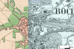
Proposer:![Transformation result of a landscape: Comparison between a Prussian original map (1827) (left) and the clearly more detailed and geodetically more exact new map (1894) (sheet 2577 [4905] Bochum (right); original scale 1:25,000.](/mam/kartographie/projekte/industriezentren/fittosize_1078_0_636_154_10f514f11d65362faf695de13c56180d_bochum-transformation.jpg "Transformation result of a landscape: Comparison between a Prussian original map (1827) (left) and the clearly more detailed and geodetically more exact new map (1894) (sheet 2577 [4905] Bochum (right); original scale 1:25,000.")
The georeferencing of the map sheets and the systematic inventory of topographic spatial elements were carried out with the help of GIS technologies. Due to the complex digitisation of the individual information layers of the old maps, detailed cultural landscape analyses of the space can be carried out, especially with regard to the changes in land use in both study areas. Some of the results are now available online in the form of interactive maps (http://cartolandscape.amu.edu.pl/). There, maps can be displayed synchronously in two windows for comparison purposes at any scale and independent research can be carried out. In this way, users can decide how much and in what form they want to access information about the development of the cultural landscape of the "Metropole Ruhr" and the "Metropolia Silesia". Multilingual commentaries on the maps provide quick and up-to-date access not only for researchers from both countries, but also for other interested parties who want to find out about the spatial development of the industrial regions.


The DPWS project was carried out jointly by the Cartography Research Department of the Institute of Geography at the Ruhr University in Bochum (Prof. Dr. Frank Dickmann) and the Department of Cartography and Geomatics at the Adam Mickiewicz University in Poznan (Prof. Dr. Beata Medynska-Gulij). The project received important support from the Fachinformationsdienst Karten (FID) of the Map Department of the Berlin State Library, which was newly established by the DFG. Among other things, the FID provided high-resolution scans of the original map sheets for the GIS-supported evaluation.
Close coordination between the two universities was necessary to ensure that uniform evaluation and documentation criteria were observed in the map evaluations. This was achieved, among other things, through joint working meetings in Berlin (State Library) and at the universities in Poznan and Bochum. In addition to cartographic-technical aspects, the main focus was on the cultural-geographical structures of the Ruhr region and the Upper Silesian industrial district that still characterise the area today. In addition, joint excursions to the areas took place, not least to collect (among other things photographic / film) material for the web presentation and for the publications.
Medyńska-Gulij, B., Lorek, D., Hannemann, N., Cybulski, P., Wielebski, Ł., Horbiński, T., & Dickmann, F. (2019). Die kartographische Rekonstruktion der Landschaftsentwicklung des Oberschlesischen Industriegebiets (Polen) und des Ruhrgebiets (Deutschland). KN - Journal of Cartography and Geographic Information, 69 (2), 131-142. https://doi.org/10.1007/s42489-019-00018-y
Lorek, D., Dickmann, F., Medyńska-Gulij, B., Hannemann, N., Cybulski, P., Wielebski, Ł., Horbiński, T. (2018). Die kulturlandschaftliche Entwicklung polnischer und deutscher Industriezentren Bochum - Poznań, 96 S., ISBN 978-83-7986-195-8
Krótki opis projektu
Pierwsze dokładne kartograficzne opracowanie państwa pruskiego od 1822 roku objęło także część dzisiejszej Polski, ówcześnie będącej pod panowaniem pruskim. Dlatego istnieje do dyspozycji dla bardzo dużych obszarów ponadgraniczne i stosunkowo szczegółowe dzieło kartograficzne, które może służyć jako źródło do systematycznej analizy porównawczej przemian kulturowo-krajobrazowych Górnośląskiego Okręgu Przemysłowego i Zagłębia Ruhry. Tak zwane pruskie „Urmesstischblätter“ (obecnie w Bibliotece Państwowej w Berlinie) z początku XIX wieku stanowią archiwum kartograficzne, do tej pory znikomo wykorzystywane w aspekcie geograficzno-kulturowym i społeczno-ekonomicznym. Badania tej przestrzennej sytuacji kulturowo-krajobrazowej, uwiecznionej na arkuszach map, może przyczynić się do lepszego zrozumienia daleko idących społeczno-przestrzennych i ekonomicznych restrukturyzacji, którym oba regiony zostały poddane w procesie uprzemysłowienia. Po raz pierwszy mogą zastać określone kulturowo-krajobrazowe przemiany „na płaszczyźnie”. Poddane cyfryzacji Urmesstischblätter wraz z wynikami analizy kartograficznej (komentarzami, dokumentacją) zostaną udostępnione szerokiej grupie użytkowników Internetu w postaci interaktywnej multimedialnej prezentacji. Poza tym najważniejsze wyniki analizy kulturowo-krajobrazowej będą udokumentowane w wydrukowanej publikacji.
Copyright © Geographical Institute 2024
Last update: Feb 23, 2024