![]()
![]()
![]()
![]()
Development of VR-supported, model-based urban development scenarios for interaction in geography lessons
The Ministry for School and Education of the State of North Rhine-Westphalia in the Department of Cartography is supporting a three-year collaborative project to investigate the potential of VR applications in schools. This includes various techniques of spatial representation, ranging from simple 360° videos, individually controllable 3D representations on screens (smartphones, tablets) to room sections projected onto entire walls, and finally to the increasingly widespread head-mounted displays, HMD (VR glasses). By linking corresponding applications to mass-market VR headsets known from gaming, e.g. HTC Vive Pro or Oculus Rift, an innovative user experience can be created for VR applications.
The main focus of the project is to create an interactive virtual reality environment that is suitable for expanding and realistically designing the teaching of urban development topics, in particular future urban development scenarios in geography lessons. With the help of innovative visualization methods as well as preferably freely available data, a contemporary and didactically well-founded and framed platform should be made available, which enables a flexible preparation of current subject content focal points in geography lessons oriented towards the subject areas of the core curricula.
[Press Release: https://www.schulministerium.nrw/presse/pressemitteilungen/ministerin-gebauer-mit-innovativen-lernsettings-setzen-wir-neue]
In a multi-level process, the Department of Cartography, in cooperation with the Department of Didactics of the Institute of Geography at the University of Cologne (Dr. D. Wiktorin) and subject advisors of the Ministry of School and Education NRW, develops a VR urban space model or individual VR scenarios (see Figs. 1 and 2) that meet the curricular requirements and can be used flexibly in lessons throughout all grades and subjects. To enable online use with common desktop devices, the application will be created as a browser-based web application.
Project Info
Project Period: 2021 - 2024
Projekt Lead:
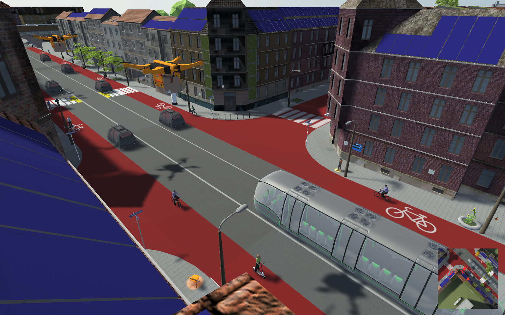
The VR environments are to enable students of secondary level 1 and of the upper secondary level to gain a new access to geographic facts and questions . It will focus on the "Smart City" with its aspects "Smart Mobility", "Smart Economy", "Smart Living" and "Smart Environment". These topics will be developed as independent interactive VR environments and are intended to familiarize the students with the state of today's urban spaces along with possible future urban development scenarios for them.
The planned project will focus on the main aspects of current urban development in Germany, taking into account historical lines of development and future scenarios - in particular those of the smart city. Aspects of demographic and social change, mobility as well as urban economic and ecological effects in the context of digitalization tendencies will receive special consideration and enable critical reflection on future urban concepts.
.")
Which form of multimediality, whether the implemented locomotion modes, the immersivity (2D display such as tablet or PC monitor, 3D VR headset) or the degree of content-related depth of information should finally be technically implemented for the individual subareas is the subject of the cooperation of the network partners participating in the project. The realization of the measures in the schools will be scientifically accompanied and evaluated.
Weißmann, M., Edler, D., Keil, J., & Dickmann, F. (2023). Creating an interactive urban traffic system for the simulation of different traffic scenarios. Applied Sciences, 13(10), Article 6020. https://doi.org/10.3390/app13106020
Weißmann, M., Edler, D., Keil, J., & Dickmann, F. (2022). The development and simulation of an urban traffic system for the usage in immersive virtual environments. Abstracts of the ICA, 5. https://doi.org/10.5194/ica-abs-5-101-2022
Keil, J., Edler, D., Schmitt, T., & Dickmann, F. (2021). Creating immersive virtual environments based on open geospatial data and game engines. KN - Journal of Cartography and Geographic Information, 2021, 1–13. https://doi.org/10.1007/s42489-020-00069-6
Edler, D., Keil, J., Wiedenlübbert, T., Sossna, M., Kühne, O., & Dickmann, F. (2019). Immersive VR experience of redeveloped post-industrial sites: the example of “Zeche Holland” in Bochum-Wattenscheid. KN - Journal of Cartography and Geographic Information, 69(4), 267–284. https://doi.org/10.1007/s42489-019-00030-2
Edler, D., Husar, A., Keil, J., Vetter, M., & Dickmann, F. (2018). Virtual Reality (VR) und Open Source Software: ein Workflow zur Konstruktion einer interaktiven kartographischen VR-Umgebung zur Erkundung urbaner Landschaften. Kartographische Nachrichten, 68(1), 3–11.
Edler, D., Kühne, O., Jenal, C., Vetter, M., & Dickmann, F. (2018). Potenziale der Raumvisualisierung in Virtual Reality (VR) für die sozialkonstruktivistische Landschaftsforschung. Kartographische Nachrichten, 68(5), 245–254.
Edler, D., & Dickmann, F. (2017). The impact of 1980s and 1990s video games on multimedia cartography. Cartographica, 52(2), 168–177. https://doi.org/10.3138/cart.52.2.3823
Copyright © Geographical Institute 2024
Last update: Feb 22, 2024