![]()
![]()
![]()
![]()
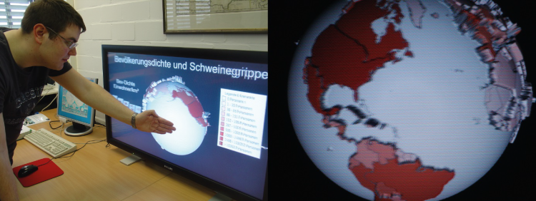
Lenticular visualisation methods offer the possibility of linking changing image and autostereoscopic representation with cartographic content. On the basis of real 3D, they have already found their way into geovisualisations of reliefs, both for analogue (print) and for digital forms of presentation (screen). So far, it has not been investigated which potentials arise for the widely used thematic cartographic representations (thematic maps). The plastically differentiated reproduction of spatial information enables a multi-layered structure and presents several parameters (or dimensions) of a cartographic content. Hence, previously unsolvable problems in cartography can be addressed and cartographic modelling can be promoted. With the help of comparative tests, the information transfer performance, which the lenticular technique in cartography is capable of, is supposed to be empirically tested and quantified for the first time. This project is being carried out in cooperation with the Institute of Cartography at the TU Dresden, which already possesses methodological experience in the field of lenticular-based relief representation.
Project Info
Project-ID: DI 771/5-1, BU 949/23-1
Project Period: 2010 - 2014
Proposer:

Although the potential of lenticular technology in thematic cartography is obviously great, there are still no studies on this. Research to date has mainly focused on the geovisualisation of three-dimensional data. However, there is a clear deficit in the systematic processing of the use of this technology for cartographic representations and the resulting information transfer performance. Up to now, the use of map representations in connection with the lenticular technique has taken place without a theoretical basis. Thematic map elements have only been examined in rudimentary form, e.g. the suitability of fonts and font sizes and their possible arrangement under lenticular transparencies. The broad spectrum of thematic cartographic forms of presentations has so far remained unnoticed.
![Own visualization according to Alioscopy (http://www.alioscopy.com/Overview [20.10.2010])](/mam/kartographie/projekte/lentikular/fittosize_1078_0_199_104_47a192b8497deb7729e0be8646b69d6e_fig2.png "Own visualization according to Alioscopy (http://www.alioscopy.com/Overview [20.10.2010])")
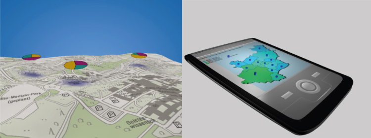
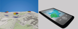
The 3D technique allows the integration of additional thematic information into a base map, for example by placing „levitating“ diagrams (see figure below) above the map base without covering important map elements such as labels or relief information. Empirical map experiments will be conducted in order to find out which cartographic presentation method (choropleth, isoline, diagram maps) can lead to more effective map use and how cartographic design elements (colours, minimum dimensions, signature design, fonts, etc.) must be adapted to the respective lenticular effects. It should be clarified which cognitive-visual barriers occur during the use of lenticular sheet maps and how these can be overcome with the help of new or varied design elements for better perception. The aim of the intended project is therefore to obtain secured data in a multi-stage process that can help to determine the efficiency of lenticular visualisation methods. This will allow their use in future cartographic tasks to be evaluated and thus more targeted. The technique is also conceivable for mobile applications.


Bröhmer, K., Knust, C., Dickmann, F., & Buchroithner, M. F. (2013). Z-axis Based Visualization of Map Elements–Cartographic Experiences with 3D Monitors Using Lenticular Foil Technology. The Cartographic Journal, 50(3), 211-217. https://doi.org/10.1179/1743277413Y.0000000063
Schmidt, J. B. H. (2013). Möglichkeiten der Lentikulartechnik als themakartographisches Visualisierungsverfahren. Dissertation. https://hss-opus.ub.rub.de/opus4/frontdoor/index/index/docId/3481
Bröhmer, K., Knust, C., Dickmann, F., & Buchroithner, M. (2012). Die Nutzung autostereoskopischer Monitore zur kartographischen Visualisierung von Diagrammen. Kartographische Nachrichten, 62(5), 227-234. https://doi.org/10.1007/BF03544490
Dickmann, F., Bröhmer, K., Buchroithner, M. F., & Knust, C. (2012). Möglichkeiten und Grenzen lentikularer Mehrbildmodelle im Vermittlungsprozess raumbezogener Informationen. In N. Diekmann-Boubaker & F. Dickmann, F. (Hg.) Innovatives Lernen mit kartographischen Medien, 129-44.
Schmidt, J. B. H. & Dickmann, F. (2011). Der Einsatz von Schrift in lentikularen Print-Karten. Kartographische Nachrichten, 61(4), 204-209. https://www.geographie.ruhr-uni-bochum.de/fileadmin/geomatik/dickmann/PDFS/Der_Einsatz_von_Schrift_in_lentikularen_Print_Schmidt___Dickmann_2011-Karten.pdf
Knust, C., Bröhmer, K., Buchroithner, M. F., & Dickmann, F. (2011). Autostereoskopische Displays für themakartographische Mehrbildmodelle. Mitteilungen des Bundesamts für Kartographie und Geodäsie, 47, 65-70.
Knust, C., Buchroithner, M. F., Dickmann, F., & Bröhmer, K. (2011, July). Autostereoscopic Displays for Thematic Maps. In Proceedings of the International Cartographic Conference (ICC), ID: CO-270, Paris, Jul (pp. 3-8). https://icaci.org/files/documents/ICC_proceedings/ICC2011/Oral%20Presentations%20PDF/C4-Geovisualisation%20-%20graphical%20issues%20and%20proposals/CO-270.pdf
Edler, D., Schmidt, J. B.-H., & Lammert-Siepmann, N. (2011). Lenticular Print Maps in Teaching Irish Mutations on Initial Consonants. Journal of Celtic Language Learning, 15, 111-119.
Edler, D.; Schmidt, J. B.-H., & Jürgens, C. (2011). Teaching Geography Using Lenticular Image Maps. In: Hill, R. A. und Baines, N. (Eds.): Earth Observation in a Changing World. Proceedings of the 2011 RSPSoc Annual Conference, 13.-15. September, Bournemouth (UK), 4p.
Dickmann, F. (2010). The potential of the lenticular foil technique for thematic cartography. The Cartographic Journal, 47(3), 250-256. https://doi.org/10.1179/000870410X12786821061459
Dickmann, F., Dodt, J., & Schmidt, B. (2009). Zum Potenzial der Lentikulartechnik in der thematischen Kartographie. Kartographische Nachrichten, 59(6), 295-302. https://doi.org/10.1007/BF03544062
Buchroithner, M. F. (2007). Echtdreidimensionalität in der Kartographie: Gestern, heute und morgen. Kartographische Nachrichten, 57(5), 239-248. https://doi.org/10.1007/BF03544036
Bröhmer, K., Knust, C., Dickmann, F., & Buchroithner, M. (2012). Die Nutzung autostereoskopischer Monitore zur kartographischen Visualisierung von Diagrammen. Kartographische Nachrichten, 62(5), 227-234. https://doi.org/10.1007/BF03544490
Dickmann, F., Bröhmer, K., Buchroithner, M. F., & Knust, C. (2012). Möglichkeiten und Grenzen lentikularer Mehrbildmodelle im Vermittlungsprozess raumbezogener Informationen. In N. Diekmann-Boubaker & F. Dickmann, F. (Hg.) Innovatives Lernen mit kartographischen Medien, 129-44.
Dickmann, F. (2010). The potential of the lenticular foil technique for thematic cartography. The Cartographic Journal, 47(3), 250-256. https://doi.org/10.1179/000870410X12786821061459
Dickmann, F., Dodt, J., & Schmidt, B. (2009). Zum Potenzial der Lentikulartechnik in der thematischen Kartographie. Kartographische Nachrichten, 59(6), 295-302. https://doi.org/10.1007/BF03544062
Buchroithner, M. F. (2007). Echtdreidimensionalität in der Kartographie: Gestern, heute und morgen. Kartographische Nachrichten, 57(5), 239-248. https://doi.org/10.1007/BF03544036
Copyright © Geographical Institute 2024
Last update: Feb 23, 2024