![]()
![]()
![]()
![]()

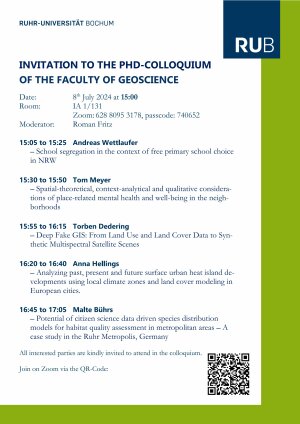
Date: 8th July 2024 at 15:00
Room: IA 1/131
Zoom: 628 8095 3178, passcode: 740652
Moderator: Roman Fritz
15:05 to 15:25 Andreas Wettlaufer
15:30 to 15:50 Tom Meyer
15:55 to 16:15 Torben Dedering
16:20 to 16:40 Anna Hellings
16:45 to 17:05 Malte Bührs
All interested parties are kindly invited to attend in the colloquium.
LIST OF ABSTRACTS
Andreas Wettlaufer
Primary school segregation is one of the key challenges in urban and education policy, as schools with a high proportion of pupils from lower-class families are likely to face negative context effects, which in turn reinforce educational inequalities (Musset 2012).
A city’s primary school segregation is closely related to its residential segregation (Tammaru et al., 2021). However, in education systems that allow primary school choice, parental choice often further reinforces school segregation (Wilson and Bridge, 2019). With the introduction of free primary school choice in 2008, NRW was the first federal state in Germany to completely abolish catchment areas. Therefore, the question arises as to whether there is also a segregation-inducing effect of the reform. To answer this question, the presentation draws on administrative data from a large city in NRW. Moreover, based on an online survey of parents of first and second graders in a selected district of the city as well as qualitative interviews with
parents and experts (headteachers, representatives from the school administration etc.) the presentation explains how parental choice contributes to school segregation in detail. In doing so, it addresses several research gaps, among others, which role reputation and extracurricular activities play for socially selective school choice decisions.
Results show that, in addition to residential patterns, parental school choice indeed boosts the uneven distribution of pupils with the decisions of middle- and upper-middle-class parents against schools with a high share of lower-class pupils/bad reputation particularly contributing to this. On top of this, segregation is exacerbated by the choices of lower-class parents who focus more on school support services, which they tend to locate at disadvantaged schools.
Tom Meyer
Health inequalities have become more entrenched in society in recent decades. Depression in particular is an increasing challenge in urban areas. From a geographic perspective, this raises the question of the extent to which people's neighborhoods are of particularly importance for their mental health and well-being. In this presentation, I will briefly outline the three phases of my dissertation. First, I show how the relationship between space and mental health has been conceptualized according to spatial theories and how blind spots exist (review). Second, I use a regression-analytic context effect study on neighborhoods in the Ruhr area to show which factors influence the probability of depression in the neighborhood (quantitative analysis). Finally, the results of the first and second analytical steps flow sequentially into the third phase of the dissertation, in which I analyze the pathways between neighborhood and mental health along a multi-layered understanding of space, considering dimensions, experiences, and productions of space on the basis of problem-centered interviews (qualitative approach).
In summary, the results of the three phases of my dissertation suggest that in addition to material inequalities in space, social disparities and regulatory factors as well as individual experiences of neighborhoods over time should be given greater weight in the analysis of the relationship between space and mental health or mental well-being in neighborhoods, as well as in future health policies and urban development processes.
Torben Dedering
AI and deep learning methods have become essential approaches for land use and land cover (LULC) classifications, which are important in urban planning and regional management. While the extraction of LULC information from multispectral satellite images has been a well-studied part of past and present research, only a few studies emerged about the recovery of spectral properties from LULC information. Estimates of the spectral characteristics of LULC categories could enrich LULC forecasting models by providing necessary information to delineate vegetation indices or microclimatic parameters. We train two identical Conditional Generative Adversarial Networks (CGAN) to synthesize a multispectral Sentinel-2 image based on different combinations of open-source LULC data sets. Large-scale synthetic multispectral satellite images of the administrative region of Bonn and Rhein-Sieg in Germany are generated with a Euclidean distance-based patch-fusion method. The approach generated a realistic-looking satellite image without noticeable seams between patch borders. Based on several metrics, such as difference calculations, the spectral information divergence (SID), and the Fréchet inception distance (FID), we evaluate the resulting images. The models reach mean SIDs as low as 0.026 for urban fabrics and forests and FIDs below 90 for bands B2 and B5 showing that the CGAN is capable of synthesizing distinct synthetic features matching with features typical for respective LULC categories and manages to mimic multispectral signatures. The method used in this paper to generate large-scale synthetic multispectral satellite images can be used as an approach to support scenario-oriented sustainable urban planning.
Anna Hellings
Urbanisation is a global phenomenon that has significant implications for climate and environmental conditions. As cities expand and develop, natural landscapes are increasingly replaced by built environments, leading to various ecological and climatic challenges. One of the most pressing issues is the formation of (Surface)Urban Heat Islands (SUHIs), where urban areas experience higher temperatures than their rural surroundings. This effect is exacerbated by climate change, which is intensifying heatwaves and making urban centers more vulnerable to extreme temperatures.
This dissertation examines the influence of urbanisation and land use changes on Surface Urban Heat Islands (SUHIs) in Europe over recent years. It investigates whether SUHIs and heat anomalies have become a growing problem due to urbanisation, particularly affecting urban centers more than rural areas. The research explores whether land use changes have consistent effects on land surface temperatures (LST) across all Functional Urban Areas (FUAs) in Europe, analysing variations in LST changes due to different types of land use and development patterns. In the second part, the study have a look into the historical development of Local Climate Zones (LCZs). To achieve this, a multitemporal dataset of LCZs for European cities is calculated and will than examine the evolution of LSTs within various LCZs to identify patterns and factors influencing temperature dynamics. Based on these two first steps, the dissertation will modell the future development of LCZs under different urbanisation and climate scenarios, assessing the potential impacts on urban climates. This includes exploring how changes in policy, urban planning, and environmental management could influence the future state of cities and their climatic conditions.
Malte Bührs
Citizen science and remote sensing approaches have become more reliable, thus providing higher resolution and generating a large amount of environmental data. When considering urban environments, where fragmented and highly diverse landscapes are predominant, the combination of citizen science data and remote sensing techniques with species distribution models can play a vital role in comprehensively investigating and evaluating urban biodiversity. However, citizen science-derived species distribution models for multiple avian species in dense and fragmented urban areas are rarely used.
Citizen science-based datasets of 26 breeding bird species over three years were obtained for this analysis in Germany’s Ruhr Metropolis. Spatial data from the ecosystem LiDAR project GEDI (Global Ecosystem Dynamics Investigation), climate data from the German Weather Service, and land use information from Copernicus were used as environmental predictors. Eleven different species distribution models (SDMs) were trained on species subselection by using Biomod2 for preliminary analysis. Finally, four species distribution models were used for ensemble modelling. Subsequently, a species richness analysis was performed with the aim of identifying spots with high avian biodiversity which aids in optimizing urban development concepts and (sub)urban green space management with respect to urban biodiversity conservation.
These text for download [PDF]
Copyright © Geographisches Institut 2024
Letzte Änderung: 01. Jul. 2024