![]()
![]()
![]()
![]()

Around 10,000 active satellites orbit our planet every day and fulfil a variety of tasks. They transmit data that is essential for the functioning of the internet, play a key role in navigation and provide high-precision images of the earth. Modern satellites achieve a geometric resolution of up to 0.25 metres - so detailed that you could even recognise a basketball from space. It is therefore hardly surprising that interest in unmanned space travel is constantly growing. Remote sensing data harbours enormous potential for various areas of society, such as agriculture, fisheries and forestry, urban and regional planning as well as nature and environmental protection. Nevertheless, this data hardly reaches the general population, even though it is usually freely accessible. It is crucial for innovation to get this data out of the silos of experts and billionaires and to empower people to utilise these data sets. The aim of the workshop at re:publica was therefore to sensitise people to the benefits of remote sensing data and its importance for combating climate change and to provide easy access to these data sources.
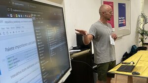
After a brief thematic introduction by Nicolai Moos from the Institute of Geography, the participants were able to familiarise themselves with and try out the various possible applications of satellite data using a variety of examples such as the deforestation of the Amazon rainforest and the melting of the Aletsch glacier. The subsequent exploration of the participants' own home town was particularly exciting, and each participant was able to complete the tour with a souvenir.
The positive feedback and high level of interest clearly showed that satellite data offers an exciting and low-threshold introduction to data and digital literacy.
The materials and a brief description of how to install the necessary software packages can be found here: https://ruhr-uni-bochum.sciebo.de/s/ObcMC5LO6QJ04hs#editor
Copyright © Geographical Institute 2024
Last update: Jun 10, 2024